Walk 550 - Windsor Great Park

Obelisk Pond with ice on its surface and hoar-frost on the surrounding trees.
After an Autumn with temperatures well above the seasonal average, Winter has started with a vengeance by being a lot colder than usual for this time of year. We had a week of freezing temperatures and on Sunday 11th December, the day of Kathy and Ann's walk, the temperature stayed below zero throughout the day.
Five walkers, including the two leaders, braved the sub-zero temperatures at Windsor Great Park. This was originally going to be a nine mile walk, but given the weather conditions, the group decided to shorten the walk to approximately five miles.

The local spiders are having a hard time with their frozen webs.
During the pre-walk, it was discovered that the car parks and parking areas around the Great Park are now charging a significant amount for parking. We also discovered that one of the routes we wanted to take on Queen Anne’s drive was closed. As a result, we chose a new starting point on Ridgemead Road where there was free parking available in the residential area, and where we could access our route from Bishopsgate.

A Winter Fun Fair at the Savill Gardens.
We made our way to the Bishopsgate entrance where we picked up our original route and made our way past Cookes Hill and Spring Hill on our right, and Snow Hill on our left. We crossed over the Three Castles Path, making our way to Richardson’s Lawn. The wide paths were quite slippery and we had to take care to avoid the ice. It was extremely foggy, so the views were very limited today.
We left the Three Castles Path and headed to Cumberland Lodge, making our way to Savill Gardens where we stopped for lunch and coffee. Leaving Savill Gardens we headed back to Bishopsgate and back to where we had parked.
Thank you to Kathy and Ann for leading the walk, providing the photos and writing it up.
Walk 549 - Woolhampton, Midgham and our Christmas Lunch

Autumn colours on show in Midgham Park.
On Saturday 3rd December we did a short walk (about 5 miles) before our Christmas lunch at The Rowbarge pub in Woolhampton. Seventeen people were on the walk and a few more joined us afterwards for the meal. The day was a rather cold and grey, so most of us were wearing our hats and gloves for the first time since the unusually mild autumn. (I forgot to bring mine!)
The walk started at Midgham railway station, which isn't actually in Midgham - it's in Woolhampton. Heading up Station Road, we crossed the A4 Bath Road and headed up the rather steep and narrow Woolhampton Hill road to Upper Woolhampton. This spurt of energetic exercise soon warmed us up!

Stopping to look at St Matthew's Church in Midgham.
Leaving the road, we headed west and north through fields and woodland to Channel Wood, where we stopped for a drink/snack break. We gathered under a large oak tree and munched on our cereal bars, etc. Some people had brought hot drinks in flasks. (I forgot to bring mine!)
Suitably refreshed, we continued the walk, heading south and west through Midgham Green and into Midgham Park. There were still plenty of yellow and brown autumn leaves on the trees despite the large amount of them carpeting the footpaths.
Emerging from the park into the village of Midgham, we stopped to look at the rather imposing parish church of St. Matthew, built in 1869 in the 13th century style.

Following the Kennet and Avon Canal near Cranwell Bridge.
Being on a hill, there were good views from the church grounds. Amongst the recognisable landmarks, we could see the Hannington tower and Watership Down, where we'd been on a walk quite recently. We headed downhill to Midgham Marsh, crossing the A4 Bath Road again and joining the Kennet & Avon Canal towpath at Midgham Lock.
The rest of the walk followed the canal towpath eastward back to Woolhampton. The towpath changed sides a couple of times at Cranwell Bridge and Oxlease Bridge before entering the large garden of The Rowbarge pub. See our route on Google Maps. We arrived in plenty of time to change out of walking gear and get a drink at the bar before sitting down for lunch. The food was good and so was the company.
Thank you to Mike and Alison for leading the walk and to Mike and Jane organising the Christmas Lunch.
Walk 548 - Finchampstead and Moor Green Lakes

Following the muddy path through Wick Hill.
Eight of us decided to brave the gloomy weather on Sunday 27th November and met up in Finchampstead for an 8 mile walk. As happens quite often, the gloomy sky didn't turn to rain, except for a very brief sprinkle toward the end of the walk.
We set off along Nine Mile Ride, but very soon switched to Wick Hill Lane, which turned from a lane into a muddy track before long. This we followed until it joined another lane call Goose Green. This led us to Dell Road, which took us into the autumnal woodland of Finchampstead Ridges. There were some useful board-walks over the more soggy bits of ground, which had been installed many years ago by volunteers, one of whom was on our walk. We much appreciated Neil's handiwork.

More muddy paths at Fleet Copse.
Leaving The Ridges via Drift Lane, we then followed Lower Sandhurst Lane before entering Moor Green Lakes nature reserve. We headed south to join the path that runs parallel to the River Blackwater, which we followed westward for about a mile.
After crossing the B3016, our path curved northward back toward Finchampstead. A wide and muddy track took us to Longwater Lane, where a narrow footpath took us north to Finchampstead Sports Club. Here we stopped for our picnic lunch, using some of their benches that faced an empty cricket pitch. After lunch, we followed a footpath up the hill to St. James' Church.

Longmoor Lake at California Country Park.
Our leaders, Ann and Kathy, pointed out an oak tree planted 20 years ago for the golden jubilee of Queen Elizabeth II and told us of another oak that had recently been planted nearby to commemorate her death. We continued northward to California Country Park, where we stopped at the café. Being such a mild day for the time of year, we sat outside with our hot drinks and cake, before circumnavigating Longmoor Lake.
A number of new paths have been laid in the park since our last visit. Elizabeth, who lives locally, said she would lead us through the new paths. We emerged on Gorse Ride near the junction with Nine Mile Ride and it was a short walk along these roads back to the car park. See our route on Google Maps.
Thank you to Ann and Kathy for leading this walk and Elizabeth for leading the final section.
Walk 547 - Pangbourne, Sulham Wood, Tidmarsh and AGM
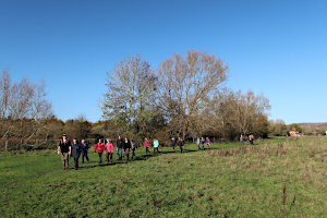
Leaving Pangbourne village and crossing the moor.
On Sunday 20th November, we did a six-mile walk which was followed by our first Annual General Meeting. The walk was a shortened version of a walk I'd led at the beginning of the year, which would finish in the early afternoon to give time for the AGM. Despite the pessimistic weather forecast, we had blue skies for most of the walk.
Twenty-one people turned up for the walk and a few more joined us afterwards for the AGM. We started the walk by leaving Pangbourne village on a lane called The Moors, next to WH Smith. This led us past several cottages and out onto the moor.

Sulham Wood, after a steep climb.
Having crossed the moor, we followed Sulham Lane for a short distance before crossing a field and taking the steep path into Sulham Wood. The path had some steps cut into it on its steepest section, which really helped. The ground can be quite slippery at this time of year. After stopping to get our breath back, we followed a much more level path northward through the woodland to Mosshall Wood.

Crossing Hallplace Farm, near Little Heath.
Out in the open again, we followed a long path southward across fields to Vicarage Wood. A short walk along a twisty, narrow lane took us to more fields as we followed a route to Hallplace Farm, near Little Heath.
Almost doubling back, we re-entered Sulham Wood at the southern end. A woodland path took us gently down hill to a spot where there we many logs and fallen trees at the edge of the wood. A perfect spot for our picnic lunch.

Our first Annual General Meeting.
After lunch we crossed fields and the River Pang to reach the hamlet of Tidmarsh. From there we briefly followed the main road and then took a footpath that led us past the Old Rectory and across fields. We crossed the River Pang once more and were back at Pangbourne Moor. From there, we retraced our outward route back to the car park, arriving just before a rain shower. See our route on Google Maps.
After the walk there were cakes, cookies, tea and coffee at the village hall to celebrate our tenth anniversary. We also held our first AGM and elected our new committee. We are now a constituted group within the Ramblers after ten years of operating as a flexi-group.
A big thank you to all the volunteers who helped with the AGM.
Walk 543 - Kingsclere, Sydmonton and Ecchinswell

Descending from Watership Down to Sydmonton.
There was a definite autumnal feel to the weather on Sunday 30th October as eleven of us meet up at the free car park on White Hill, near Kingsclere. The stiff breeze carried the odd drops of rain, which foretold what was approaching.
We set off along the tops of Cannon Hill Down and Watership Down, where we reached the highest point of the walk. Then we descended into the valley and out of the wind. We walked through the Sydmonton Estate, home of Andrew Lloyd Webber - we didn't see him, or anyone else for that matter.
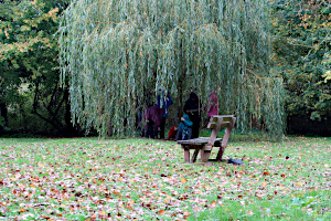
Hiding from the rain during our lunch stop in Ecchinswell.
Passing through Watership Farm, we made our way to Ecchinswell. The rain began just as we approached the village. We stopped in a little green to have our packed lunches, and the rain kept coming and going in waves. At one point, the bench was abandoned in favour of standing under a tree for shelter. As soon as we'd finished lunch we got moving again, passing through the village and then through farmland.
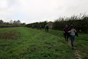
Braving the rain as we passed through Porch Farm.
We passed some fishing lakes at Frobury Farm. Fishermen were sitting in specially designed tent-like shelters and as they waited patiently for a bite. As we plodded through farmland on our way to Kingsclere, we could see blue sky behind us as the rain beat down.
Just as we reached Kingsclere the rain passed us and a rainbow heralded our arrival. We emerged from Frogs Hole (not as disgusting as it sounds - it's just a lane) onto the main road, which we followed into the centre of the village and to The Crown pub.

The rain changed to sun as we reached Kingsclere.
They had an outdoor seating area that was semi-covered. This was perfect for us, as we could sit there in relative shelter, dripping away without making the pub's floor wet. Hot drinks were available there, too. Suitably refreshed, we continued the walk, stopping briefly by the church to admire the weather-vane, which was in the shape of a bed bug!
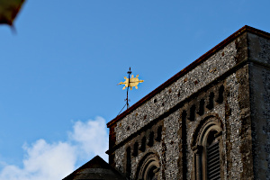
Bed-bug shaped weather-vane on Kingsclere church.
Pat, one of our regulars, told us she'd heard a story that during the 13th century, King John and his entourage had been caught in thick fog while travelling by, and they'd stopped in the village overnight. The King was troubled by bed bugs all night and decided to have a weather-vane erected on the village church to commemorate the experience. Unpleasant as it sounds, I think it actually looks very good in gold against the blue sky.

Ascending Cottington's Hill at the end of the walk.
We left Kingsclere by crossing the recreation ground and then carefully following the footpath through the gallops at Park House Stables, owned by racehorse trainer Andrew Balding (brother of TV's Clare Balding).
Next came the steep ascent of Cottington's Hill, the second highest point on our walk. We took a diagonal path up the side of the hill through the mixed woodland of Freemantle Park Down. At the top of the hill, we could see across to Newbury.
It was then a short and mainly downhill walk through farmland, back to the car park on White Hill. See our route on Google Maps. With all the ups and downs, we did 1,560 feet (475m) of ascent in total over the 9.5 mile (15.3km) walk. A good workout!
Rob led this walk and wrote it up.
Walk 542 - Tadley Common and Mortimer West End

Tramping through the Autumn leaves in Roundwood Copse.
Eleven of us, including two newcomers and a recent joiner, assembled in the free car park by Tadley Common on Saturday 22nd October. After a fairly wet week, this was a warm and sunny day, if a little muddy underfoot.
We started this nine-mile walk by crossing Silchester Road into the grounds of Tadley Calleva Football Club; exiting the other side into common heathland. Then we took a leave-covered woodland path through Roundwood Copse.

Following a track through Benyon's Inclosure.
A short footpath through an industrial park brought us to Benyon's Inclosure, part of the Englefield Estate. We took a route that wandered around the various paths in this area of mixed woodland. At one point we stopped for a coffee break, using a fallen tree as a bench to sit on.
Leaving the woodland of Benyon's Inclosure, we crossed farmland around Mortimer West End, where we saw some lovely Autumn colours on the trees in West End Farm.

Some autumnal colours on show in Mortimer West End.
A tunnel-like path through Simm's Copse took us downhill on a narrow and slippery path, which was made more hazardous at one point where there were dangling bramble creepers were trying to catch us.
Back in the open, we crossed grassy fields and a small farm with an interesting mix of donkeys, sheep and alpacas. Then we found ourselves in the National Trust car park at Wall End, quite close to the Roman remains of Calleva Atrebatum.

Darth Vader! An unexpected sight in Silchester Common.
Here there was a picnic table and benches, so we stopped here to eat our packed lunches before heading towards the Roman remains. We didn't follow the ancient walls, as we have done on may other walks in this area, but instead made our way to Silchester village. On our way to Silchester Common, we saw a slightly unexpected sight - Darth Vader brandishing his light-sabre on a branch of a tree! Presumably this was one of the entries for the Silchester Scarecrow Trail.
Crossing Silchester Common brought us back to Tadley, where most of us stopped at The Pelican pub for a drink before the final half-mile through Tadley Common returned us to the car park. See our route on Google Maps.
Thank you to Pat for leading this walk.
Walk 540 - Cholsey, South Moreton and the Astons

A distant view of Wittenham Clumps.
Seven of us set off from Cholsey Station on a fine Sunday morning. I was concerned at first when thirty-odd walkers descended down the stairs at the station, but they were part of a meet-up group from London who organise "walks by water". They pay five pounds for this opportunity apparently - but I'm available for free so perhaps this is indicative of my leading ability!
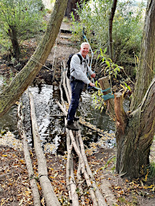
An interesting way to cross a stream.
We first headed to Saint Mary's, a large historic church which was an Abbey Church that was established in 975. We then headed down Church Road before turning off onto a footpath that headed across fields, crossed over Hithercroft Road and down to Mill Brook. As we crossed the fields we were fortunate to have excellent views of the Wittenham Clumps in the distance.
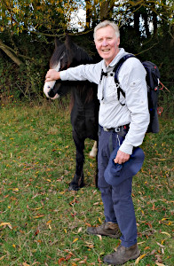
Ian making friends with the locals.
We then followed the brook towards South Moreton, passed under the railway line and made our way to The Crown Hotel where we stopped for tea, coffee and substantial servings on hot chips. The pub had been closed for a period and is now owned by locals who are shareholders. Recommended for a visit.
After passing South Moreton church we headed west and continued to follow Mill Brook before turning South along the oddly named "Vale of White Horse". We decided to take the shorter route back home in view of the time. We then took the opportunity to explore Blewburton Hill, the site of an old hillfort, before heading east, towards the Astons

Agatha Christie's grave at St Mary's Church.
Here we decided to check out the offerings at the newly re-opened Chequers Hotel. It is jointly owned by Tim Henman and other local families and has been renovated extensively. Another recommended stop off where we enjoyed our cool drinks whilst sitting in the sunshine.
We then made our way back to Cholsey passing through St Marys where we checked out the grave of Agatha Christie. A pleasant walk of nine miles - a short walk for the leader who usually underestimates his distance!
Thank you to Ian for leading this walk and writing it up.
Walk 539 - Streatley, Aldworth and Ashampstead

On our way from the Ridgeway to Aldworth.
On Saturday 1st October, ten of us (a mix of regulars, not so regulars and newcomers) met up at the car park on Streatley Hill. Ian, our leader, appeared minutes before the start time for the walk, having yomped up the hill on foot from Goring & Streatley railway station. Luckily the trains from Reading were still running, despite a major rail strike covering most of the country.
We started the walk by crossing Goring and Streatley golf course and joining The Ridgeway on Rectory Road. We followed this for a short distance before turning off and heading south-west towards Westridge Green.
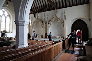
Inside St Mary's Church, Aldworth.
Three miles into the walk, we arrived at the village of Aldworth. A short distance south of the village is St Mary's Church, where Ian gave us a tour of the churchyard, pointing out where poets had been buried. Inside the church were the "Aldworth Giants" - larger than life stone effigies of medieval knights of the De La Beche family. Many of the giants were damaged by Parliamentarian iconoclasts during the English Civil War of the 17th century. Ian's walks are often educational.

On our way to Ashampstead Green.
A mile further on, we reached Portobello Wood and a section of Grim's Ditch. From there it was mostly woodland paths that took us to Ashampstead Green and then to Cassy's Field Farm Shop, where we purchased tea and cake to augment our packed lunches, which we consumed in an adjacent picnic area.
After lunch we visited St Clemet's Church in Ashampstead village. Ian told us about the mediaeval wall paintings that can be seen in the church. These had been hidden by plaster since the 16th century but were rediscovered in 1886 after a great storm when the plaster began to fall from the walls, revealing the hidden treasures.

Walking through Bowler's Copse.
Leaving the village, we followed paths through woodland and fields, passing by Hartidge Lye Wood and crossing through Bowler's Copse and Broom Wood. Then a section of road walking on quiet lanes took us to Tombhill Row.
Some more road walking brought us to Stitchens Green, which was followed by a long slog up the south side of Streatley Hill. After getting our breath back, we began to cross Common Wood. Ian offered an option to take a short detour to a good view-point that overlooked Goring and Streatley. We took up the offer and the view was indeed worth it.

A view of Goring and Streatley from Common Wood.
At the view point, we were joined by a spaniel-type dog who seemed to be lost and in some distress. It kept running up to each of us and yelping. We waited for an owner to come along the path, but no one appeared. The dog followed us back up to Common Wood and once we'd gone through a swing gate, the dog seemed to know where it was. It ran off with much determination along the main path. This was the same path we took and along the way we met some other walkers saying they'd seen someone further up with a lead and no dog.
A woodland path brought us back to the car park on Streatley Hill. See our route on Google Maps. Our route covered 11 miles with 662m (2,170ft) of ascent in total.
Thank you to Ian for leading this walk.


